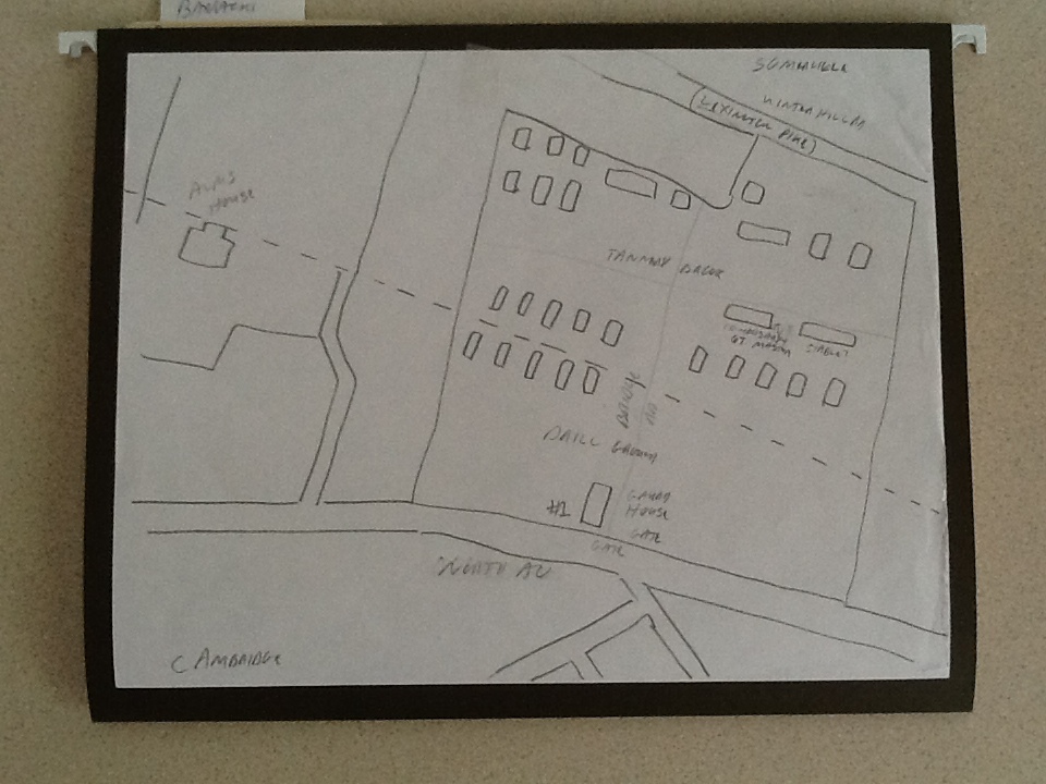
I adapted this from a map at the Cambridge Historical Commission. It was drawn onto an existing map. It is believed it was intended for the Cambridge City Directory, but never used. It is believed it was intended for either the 1862 or 1863 directory. I have added some features that I have learned. The building at the bottom on North Avenue, now Mass Ave, was referred to as the Gate House & Guard House. The 15 buildings along the dotted town line were barracks. They each held one company. From the history of the 1st Light Battery I know the two buildings above the single row of barracks on the right were the Commissary & Quarter Masters Dept. The other was a Stable. A dirt road ran through the center from North Avenue northward. Behind the barracks ran Tannery Brook. In the late 1800's Somerville and Cambridge submerged it and made it part of the drainage system. Although I have not identified the other individual buildings, I do know they contained officers quarters, at least one other stable, a hospital and a brig. According to the Lowell Courier a line of tents existed along the brook and were used by the cooks. I have also found two references to the buildings being numbered. The Gate House was #1. A member of the 38th Regiment wrote a letter to the Cambridge Chronicle in which he states his company was housed in building #8. Early in the camps history I have found references to men being appointed to command the camp. These appointments lasted only a few weeks with the state shuffling men around and then to the front. As time went on it seems that they fell into a system were the senior officer from the regiments stationed in the camp was the commander. So it is likely that policies changed with every new regiment. Since both of these references to numbered buildings comes from the same period but from two different men it is possible that it was not a designation the buildings had for the full 20 months.
DAN SULLIVAN
No comments:
Post a Comment